
 |
|
|
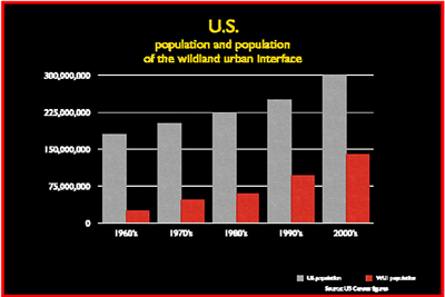
• There are more than 220 million acres in the United States that have been designated as high risk for wildland urban interface (WUI) fire. Since 1990, the conversion-growth rate of wildlands to wildland urban interface has reached unprecedented levels in the U.S.: an average of two million acres per year, 4,000 acres per day and three acres per minute.
• Those 220 million acres of WUI are overlaid with 46 million single-family homes, several hundred thousand businesses, and a population of 120 million. This demonstrates the magnitude and the complexity of the growing WUI fire protection problem facing the United States.
• Nearly 100,000 wildfires burn approximately seven million acres of land each year. Most of the past century's wildfire activity has been seasonal in nature. However, recent years have proven otherwise and we have experienced fire activity in every month of the calendar year.
• Since 2000, an average of 2,600 structures are destroyed by wildfire each year.
• Firefighting costs top $4.7 billion per year. The average annual cost for federal agencies is $2.5 billion per year; for states, $1.2 billion per year; and for local jurisdictions, $1 billion per year.
• Homes with the highest risk of burning are those adjacent to wildlands situated on the perimeter of housing developments. Interior homes situated less than 15 feet apart also are at high risk from wildfire. All homes, regardless of their value, can be best protected from wildfire by implementing appropriate loss reduction measures.
• The International Wildland Urban Interface Code (IWUIC) contains a process to evaluate the level of fire risk at individual properties. Based on this level of fire risk, the IWUIC specifies several mitigation measures to address the fire risk.